
Tuesday August 6th we left the campground and headed South on I-15 towards the Great Salt Lake. (I know I said I like to drive on "red roads" instead of interstates but we wanted to get there as fast as we could so we could see the sights.)
As we drive along Bev does a fantastic job taking photos through the windshield and side window of the car. Many of the pictures in our blogs are taken that way. Sure, every once in a while we get a dead bug on the windshield in the photo but not very often.
This photo was taken as we drove South on I-15.

It was about an hour drive to Antelope Island but a scenic trip and we enjoyed the ride.

To get to the Island we had drive across a 7 mile Causeway. At the end of the causeway was this memorial of the Soldiers of the US Army and US Air Force Special Operations Command who died in the service of this great nation on 10-29-92.


Thursday October 29, 1992 four MH60G helicopters departed from Hill AFB in a joint training exercise heading over the Great Salt Lake. The joint formation departed under night visual flight rules in rainy conditions. At 9:11 pm one of the helicopters (seven min. after takeoff) impacted the Great Salt Lake just 300 yards north of causeway on the north tip of Antelope Island. The aircraft hit the water from 35 ft altitude at 130 knots, and within two seconds the aircraft exploded. Three crew members and nine passengers from the U.S. Army Rangers and USAF personnel were killed instantly upon impact.
The only survivor was the Pilot. Three Rangers paddled over one kilometer in a tiny, inflatable raft, on choppy water through a rain and sleet storm with flames burning on the water. Fighting fatigue, hypothermia and the risk of drowning in the freezing water, they continued their efforts to search for and rescue survivors. These three Ranger were awarded the Soldier's Medal for Heroism.
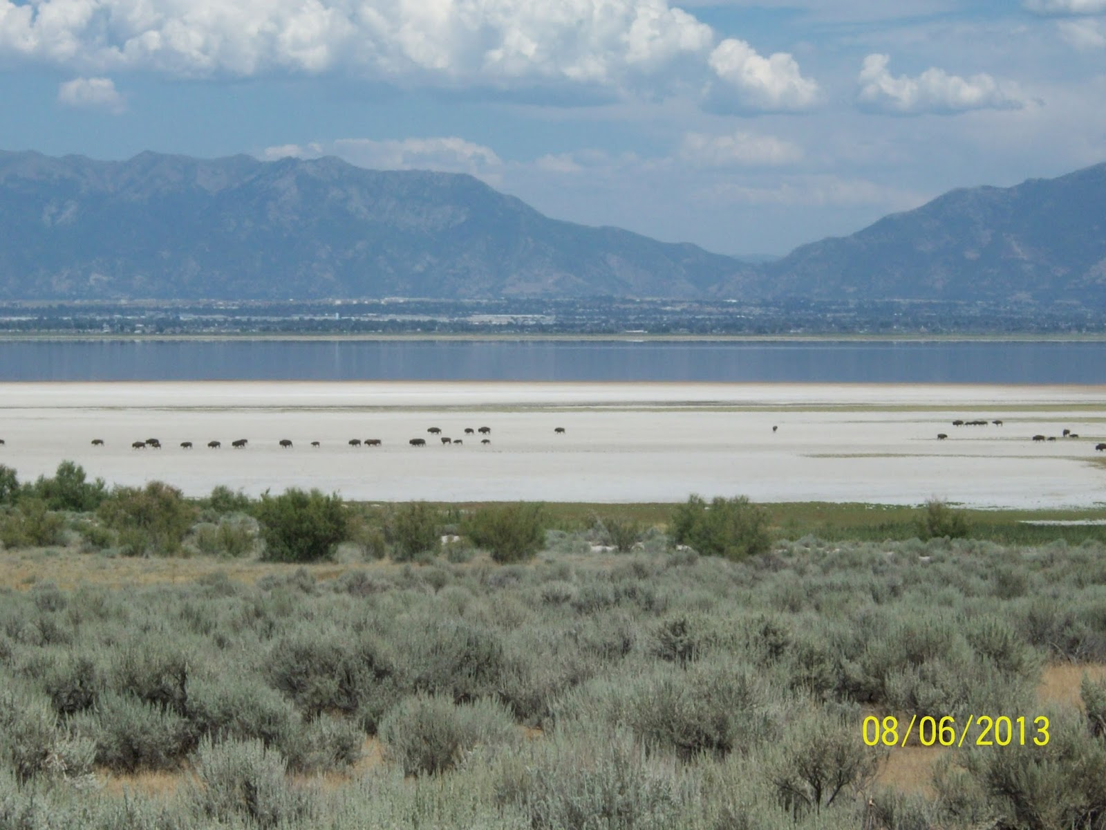
This is a view from the memorial looking South over the Great Salt Lake.

More pictures from the monument.


You can see the visitor center on the hill.

Antelope Island is the largest of Great Salt Lake's ten islands. Protected by the lake, the island's relative isolation has helped preserve its unique environment, which appears today much as it did when Mormon pioneers first arrived in the Salt Lake Valley.
I believe I remember my buddy Pete telling me that he and Judy drove out here when they were in the area a few years ago. I could be wrong but that's my story and I'm sticking to it.
We were greeted by this guy.

The Hand of Man Buffalo. A symbolic representation of all lives of humans, dependent upon and supported by the buffalo over the ages, which almost caused its extinction. The turquoise hand prints over the heart and forehead symbolizes man's intervention in saving the buffalo. Turquoise green is an Egyptian and universal color associated with life and rebirth.
This is a great view of the 7 mile causeway we crossed getting onto the island. This was taken from the visitor center.

As you see the causeway fading off into the distance, imagine the days before the causeway existed - nearly seven miles of tangy saltwater separating you from the mainland.
For over 100 years, Antelope Island belonged to private industry and was virtually inaccessible to the curious public. Construction of the causeway didn't begin until February 1964. Despite sub-zero weather, the equipment drove across a sandbar to within 1 1/2 miles of the island where men and machines began an around-the clock labor to complete the road back to the mainland. The road reached the Syracuse shore three months later.
One problem still remained. The road led to nowhere. (Remember, the road ended within 1 1/2 miles of the island.) After a delay of almost 3 years, Governor Calvin Rampton signed the bill calling for the purchase of the north 2,000 acres of the island. The state built a bridge, raised the surface, leveled, widened, and paved the causeway for improved access. Antelope Island State Park opened to the public on January 15, 1969.

Hey deer - are you looking at me!
Who the heck is that guy? Oh crap, that's me and I am smiling. I am almost "giddy" inside but gravity keeps dragging my face down into a frown. Oh, well.
More views from the visitor center.


This white buffalo was standing by the visitor center. If you look closely you will see through the holes on his side marked in black.

This is a map of the island with the hiking trails. We didn't do much hiking because it was just too hot out. We did drive most of the roads on the island though.

Antelope Island comprises 28,022 acres, and is 15 miles long and 4.5 miles across at its widest point. Frary Peak is the highest point on the island at 6,596 feet above sea level.
Antelope Island has more than 40 major freshwater springs found primarily on the east side. The springs produce 36 million gallons of water each year, supporting island wildlife and vegetation.
Bison are the island's most famous residents. Twelve animals were introduced to the island in 1893 and were the foundation for today's herd of 500 to 700. An annual bison roundup is held each fall to assess the health of the herd and sell extra animals.
The island's namesake, pronghorn antelope, are native to Utah and to the island. Like all other animals on the island, they roam freely and can be seen at various locations throughout the year.
Mule deer and California bighorn sheep are the other large animals on the island. Predators include coyotes, bobcats, badgers and numerous birds of prey such as owls, hawks and falcons.
Don't expect to go fishing. There are no fish in the Great Salt Lake, it is too salty. Brine Shrimp live in the great Salt Lake though and the birds love them.
Here are some Bison down on the beach.


This is more of what we saw as we drove around the island.


This is the Fielding Garr Ranch. It is one of the oldest ranches in Utah history. From 1848 to 1981 this ranch was continually in operation. The ranch was initially established in 1848, the year after the first Mormon pioneers came into the Salt Lake valley. Fielding Garr, a widower with nine children, was sent by the The Church of Jesus Christ of Latter-day Saints to live on Antelope Island and establish a ranch to manage the church's "Tithing Herds" of cattle and sheep.
You can visit this unique history with its hands-on exhibits and step back in time with its ranch buildings.

Salt Lake City is in the distance. Salt Lake City is on the South side of the Great Salt Lake.

I believe this is Hill Air Force Aerospace Museum we passed by on our way back home to the Winnebago.

Along the way and everywhere we go in Utah we pass by the Utah Route Signs which have the route numbers on a Bee Hive. We wanted to know why.

Bev went on line to fine out why the symbol of a Bee Hive is used.
Utah is the Beehive State. (Who new?) Most of the nicknames associated with Utah are related to the members of The church of Jesus Christ of Latter-day Saints, or Mormons, that first settled in the territory. Deseret, in The Book of Mormon is actually a honeybee. Early Mormon settlers have been described as having carried "swarms of bees" with them. This nickname commemorates the industry of the people of Utah. The beehive was adopted, in 1847, as an official emblem and represents the qualities of industry, perseverance, thrift, stability, and self-reliance, all virtues respected by the region's settlers.
The beehive is the centerpiece of the Utah State Flag and the Utah State Seal.
Today we learned something about Utah.
If you were wondering, the Navajo Indians were referred to by the Apache as "Yuttahih" meaning "one that is higher up." Europeans misunderstood this term to refer to the tribes living higher in the mountains than the Navajo, the Utes, and the territory was called the land of the Utes, Utah.
Thus is our lesson for today.
I will cover a trip through Logan Canyon to Bear Lake on our next blog.
Bev and Tom livin and lovin the RV lifestyle.
No comments:
Post a Comment